
📊 Full opportunity report: The Eye Over The City: How Wide-Area Motion Imagery Works — And Where It Goes Blind on ThorstenMeyerAI.com — validation score, market gap, and execution plan.
TL;DR
Wide-Area Motion Imagery (WAMI) allows monitoring entire cities in real-time, tracking every movement over several square kilometers. It is transforming surveillance but faces physical and technical limits. The future involves integrating WAMI with radar systems for comprehensive coverage.
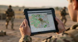
Wide-Area Motion Imagery (WAMI) is revolutionizing surveillance by enabling a single sensor to monitor entire cityscapes in real-time, tracking every vehicle and pedestrian across several square kilometers. This technology’s capabilities are already being used in military, border security, and disaster response, highlighting its growing importance in intelligence gathering.
WAMI systems, such as DARPA’s ARGUS-IS, employ an array of thousands of cameras to produce gigapixel images that cover large areas from high altitudes, allowing analysts to rewind and trace movements of individuals and vehicles. These systems are mounted on aircraft, drones, and tethered platforms, providing persistent, detailed coverage that surpasses traditional full-motion video.
Despite their power, WAMI systems face significant physical limits. They rely on optical sensors, which are affected by weather conditions like clouds, haze, and darkness, and require platforms to loiter overhead within physical reach of targets. These constraints mean WAMI cannot operate effectively in all environments or scenarios, especially where airspace is contested or denied.
To address these limitations, industry and military agencies are increasingly integrating WAMI with synthetic aperture radar (SAR), which can see through weather and darkness. This sensor fusion offers layered sensing—optical for detailed, continuous tracking, and radar for all-weather, deep-denied coverage—creating a more comprehensive intelligence picture.
The eye over the city: how Wide-Area Motion Imagery works — and where it goes blind
A normal drone sees through a soda straw. WAMI watches an entire city at once, tracks every mover, and records it all for forensic rewind. Immense reach — with hard limits that make radar and AI its necessary partners.
- City-scale motion, fine detail
- Forensic rewind
- Cloud / smoke / dark degrade it
- Needs a platform loitering overhead
sensing
+ AI
- Sees through cloud & total dark
- Tasked over denied airspace
- Persistent, wide-area from orbit
- Sovereign · on-prem · air-gap
The same archive that traces a bomber to a safe house can trace anyone home — retroactively, without prior suspicion. Baltimore’s secret 2016 deployment led to a 2021 federal ruling that persistent aerial tracking violated the Fourth Amendment. The security value is real; so is the mass-surveillance risk. Who owns the sensor, the archive, and the AI is the accountability question.
WAMI’s power is the archive and the AI reading it; its weakness is weather, airspace, and oversight. The mature posture isn’t optical-vs-radar or capability-vs-liberty — it’s layered sensing (optical WAMI + all-weather SAR), AI-enabled exploitation, and sovereign, auditable control of the whole chain. WAMI shows what a persistent eye can do with clear skies and owned airspace; for the cloud, the night, and the denied area, the radar layer is where the resilient coverage lives.
Implications of WAMI for Modern Surveillance and Defense
WAMI’s ability to provide persistent, detailed surveillance over large urban areas makes it a critical tool for military operations, border security, and disaster management. Its capacity to archive and rewind footage transforms it from a simple camera into a forensic tool, enabling investigators to trace movements and origins of targets long after an event occurs. However, its physical and environmental limitations mean it cannot replace other modalities like radar, which can operate in all weather and denied environments. The ongoing integration of WAMI with radar technology indicates a move toward layered, resilient surveillance systems that can adapt to complex operational demands.

ZOSI 3K Lite Security Camera System Indoor Outdoor,AI Human/Vehicle Detection,Night Vision,Remote Access,4pcs 1080P 1920TVL Weatherproof Surveillance Cameras,H.265+ 8CH CCTV DVR(NO HDD)
[H.265+ 8CH 3K Lite DVR 1080P 1920TVL Weatherproof Cameras] With our 8 channel H.265+ DVR and 1080P weatherproof…
As an affiliate, we earn on qualifying purchases.
As an affiliate, we earn on qualifying purchases.
Evolution and Current Use of Wide-Area Motion Imagery
WAMI technology originated in early 2000s research, notably at Lawrence Livermore National Laboratory, and transitioned to military use in the mid-2000s with systems like the Army’s Constant Hawk. It evolved through DARPA’s ARGUS-IS project and was deployed on Reaper drones in Afghanistan around 2014. Its applications have expanded from military ISR to civilian uses such as wildfire mapping and disaster response, demonstrating its versatility. Despite its advancements, WAMI remains dependent on optical sensors, which limits its effectiveness under adverse weather conditions.
“WAMI’s forensic capabilities are unmatched, allowing us to rewind time and trace movements, but weather and airspace restrictions remain significant hurdles.”
— John Marion, researcher and pioneer in persistent surveillance

MSMV High-Resolution 4K HD Camera Drone, Wireless RC Toys for Boys Girls, One Button Return, Emergency Stop, Headless Mode, 360° Flips, 2 Batteries & Carrying Case for Kids Adults Beginners, Black
This MSMV drone with camera is fitted with high-resolution 4K HD camera. As practical 4K drones with camera…
As an affiliate, we earn on qualifying purchases.
As an affiliate, we earn on qualifying purchases.
Current Limitations and Challenges Facing WAMI Deployment
While WAMI’s capabilities are impressive, it is still limited by weather, line-of-sight, and platform availability. The extent to which future AI and sensor fusion will overcome these constraints remains under active development. Additionally, legal and governance issues around persistent surveillance continue to be debated in courts and policy circles, with no clear resolution yet.

Synthetic Impulse and Aperture Radar (SIAR): A Novel Multi-Frequency MIMO Radar
As an affiliate, we earn on qualifying purchases.
As an affiliate, we earn on qualifying purchases.
Future Developments in Layered Sensing and WAMI Integration
Researchers and defense agencies are focusing on integrating WAMI with SAR and other sensors to create layered, all-weather surveillance networks. Advances in AI are expected to improve automation in data analysis, reducing reliance on human operators. Deployment of these integrated systems is likely to increase, with ongoing tests and potential fielding in complex environments in the coming years.

Advanced Intelligent Control through Versatile Intelligent Portable Platforms
As an affiliate, we earn on qualifying purchases.
As an affiliate, we earn on qualifying purchases.
Key Questions
What is Wide-Area Motion Imagery (WAMI)?
WAMI is a surveillance technology that uses a large array of cameras to monitor entire cityscapes in real-time, tracking and recording all movement over several square kilometers from high altitude.
What are the main limitations of WAMI?
WAMI relies on optical sensors, which are affected by weather conditions like clouds, haze, and darkness. It also requires platforms to loiter overhead within physical reach, and cannot operate effectively in denied or contested airspace.
How is WAMI being improved?
Researchers are working on integrating WAMI with synthetic aperture radar (SAR) and other sensors, combined with AI, to create layered sensing systems capable of operating in all weather and denied environments.
Who uses WAMI today?
WAMI is used by military agencies for intelligence, border security, and disaster response, and has been employed in civilian contexts such as wildfire mapping and infrastructure assessment.
Will WAMI replace other surveillance methods?
No, WAMI complements other sensors like radar and full-motion video, forming part of layered, resilient surveillance systems rather than replacing them.
Source: ThorstenMeyerAI.com